Archaeology Glossary

Understand the archaeological terms, tools, and concepts used in Safia's Archaeological Adventures

Artefact

(Artifact - US)

An item or object made or discarded by a human that is of cultural or historical interest. Finds from archaeological excavations or surveys are called artefacts and may include things such as jewellery, pottery, tools, weapons, animal bones, human remains, and even ancient faeces (coprolites)!


Click image to enlarge.


Image: Soft-stone vessel.

Photo: M. Ziolkowski

Backfill

When an archaeological excavation has been completed, large, open, or deeply dug areas of the site are often filled in with the spoil that was removed to protect the architectural remains or for safety (so people don’t fall into the holes in the ground!). The backfilled areas are lined with protective sheeting to prevent contamination and make it easier to remove the filling if the area needs to be opened again.


Click image to enlarge.


Image: K. Davis

Context

Every archaeological element in an excavation is given a context number and described according to location, what it is made of, and the objects that are found in it or what it is associated with. For example, it could be a layer of soil, a pit of ash or rubbish, a wall, or a pile of shells. By numbering everything it is easier to describe associations between different areas and map the site.


Click image to enlarge.


Photo: canva.com

Conservator

Someone who stabilises and investigates vulnerable artefacts and materials to prevent them from degrading. The may also reconstruct broken artefacts such as pottery. Conservators work both in the field on excavations and in a lab.


Image: A conservation lab.

Photo: M. Ziolkowski


Click image to enlarge.


Click the button for more information from Conservation Practices on Archaeological Excavations, Principles and Methods.


Electronic Distance Measurement (EDM)

A method of working out the length between two points, either vertical or horizontal. Digital instruments called total stations or theodolites bounce electromagnetic waves off a reflector or prism to precisely determine the distance being measured. A total station is linked to an external computer for data collection, while data is generally recorded by hand when using a theodolite.


Click image to enlarge.


Image: K. Davis via canva.com

Photo: canva.com


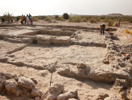
Excavation

The uncovering, processing, and recording of archaeological remains. There may be more than one excavation site on an archaeological dig.


In Past Remembrance, there is one main excavation site that includes the church, monastery living quarters, and burial.


Click image to enlarge.


Image: Sir Bani Yas excavation 

Photo credit: Department of Culture and Tourism - Abu Dhabi

GPR – Ground-penetrating Radar

GPR is a tool used for surveying beneath the surface of the ground. It transmits electromagnetic pulses (radar waves), into the ground that are detected by a receiver antenna to create a 3D image of what lies beneath without having to physically dig. It is helpful to archaeologists when there is a large area to survey to identify the best place for excavation. 


Click image to enlarge.


Image: K. Davis via canva.com

in situ

A Latin phrase that means in the original place. An artefact that is photographed in situ, is being photographed in the place it was found before being removed from the ground.


In Past Remembrance, when Safia is excavating her first important artefact (the perfume bottle), she and Saif take a photograph of it in situ before passing it over to the  conservator.


Click image to enlarge.


Image: flint tool in situ.

Photo: M. Ziolkowski.


Level staff

A pole with graduated markings used to measure differences in elevation. It is used in combination with a levelling instrument like a dumpy. One person holds the pole on the spot to be measured, while another person takes the reading.


Click image to enlarge.


Photo: canva.com

Site grid

The array of data points laid out by a surveyor over an archaeological site. The grid allows the structures and objects within the site to be located in three-dimensional space and accurately shown on maps and plans. Co-ordinates can be recorded digitally with GPS equipment or manually using an easting and northing system. 


Click image to enlarge.


Photo: canva.com

Sondage

In archaeology, this is a small test trench or pit dug to investigate and sample the various layers (stratigraphy) of an area. It is used to gather as much data about a potential archaeological site as possible with less effort and disturbance than a full excavation trench. A sondage can be expanded into a full trench if required. 


Click image to enlarge.


Photo: canva.com

Stratigraphy

The different layers in a trench that can be seen in section along the edges of an area being excavated. Archaeologists will draw a 2D plan of the stratigraphy from the various areas of a site. Using this, it is possible to determine relationships between layers in different areas. For instance, if a house with 4 rooms has burnt down, you would expect a layer of ash at about the same depth in each room. 


In a wider context, stratigraphy can be used to draw relationships between different archaeological sites using the artefacts within it. Sometimes, even the type of deposit can be used, such as the pumice layers from the eruption of Vesuvius in Pompeii and Herculaneum. This is particularly useful for 'relative dating', much like how palaeontologists compare fossil layers, or geologists compare rock layers to work out if material was deposited earlier, at the same time, or later in relation to a particular layer. 


Click image to enlarge.


Photo: canva.com

Surveyor

In archaeology, a surveyor is the person responsible to laying out the site grid and mapping the site in three-dimensional space using a variety of tools and methods. They will often use GPS and computer equipment, to undertake this task. In the past, the angles, heights, distances, and relationship of objects to the grid was done manually. 


In certain instances, manual methods may still be used. For instance, in Past Remembrance, Safia is asked to take a measurement off a line to a point at the bottom of a trench. As the level of the line is known from setting up the site grid, it is possible to work out the depth of the trench in space by adding the distance from the line to the base to the trench to the known level of the line. This can be done with a tape measure and a plumb bob. 


Click image to enlarge.


Photo: canva.com

Tripod

A three-legged stand. In archaeology, a tripod may be used to support a piece of surveying equipment like a theodolite or dumpy.


Click image to enlarge.


Photo: canva.com

Trowel

A pointing trowel is traditionally used for bricklaying. It is also the perfect tool for removing archaeological deposits in a straight, level line due to the flat shape of the blade. Most archaeologists develop a strong relationship with their trowel and are very protective of it.


In Past Remembrance, we notice this starting to develop in Safia when she calls to her father to pass up her trowel after she forgot to put it in her back pocket after leaving a trench. 


Click image to enlarge.


Photo: canva.com

Print | Sitemap
©2023 - 2024 Katia Davis | Michele Ziolkowski - Safia's Archaeological Adventures.
This website uses British English.
Past Remembrance cover design, illustration, and promotional banners/graphics by Holly Dunn of Holly Dunn Design.
Resource illustrations as stated.
Website title graphics via subscription user license - canva.com and includes some AI elements.
Map style from snazzymaps.com using Googlemaps.