Left and top right - Decorated plaster fragments from east end of the church (Beech, 2019, pp. 14-15).
Bottom right - Plaster decoration from exterior of the church (Beech, 2019, p.16).


Sir Bani Yas offers far more history than we discuss in Past Remembrance. With a complex makeup and a diverse background, Sir Bani Yas shows us island communities in the UAE have existed for thousands of years.
Location and Geology
The island of Sir Bani Yas is approximately 170km west of the Emirati capital, Abu Dhabi and is 17.5km long by 9km wide. Geologically, the island comprises a salt dome plug in a central mountainous region. Approximately 100 million years ago, activity along faults and weaknesses in the overlying limestone allowed salt to rise. From 6km below sea level, this activity pushed the salt deposits upwards to form the dome. Much of the salt dissolved on the surface, but mounts of salt, up to 150m high, loom large (Beech, 2009, pp. 99-100; Aston, 1985).
 Image: Maps showing the location of Sir Bani Yas Island and main locations from the novel. K. Davis
 Image: A salt mount, Sir Bani Yas, Photo: canva.com
Deposits of calcareous sandstone, gypsum, shales, siltstones, and a variety of volcanic rocks are also present. The mountainous area is high in copper and iron deposits, giving the landscape a contrasting dark brown and pinkish appearance (see image below). At the foot of the mountains lies a fringe of boulders, pebbles, and gravel from erosion. Modern beach sands have blown in against this rocky fringe and form drifts (Beech, 2009, pp. 99 -100; Elders, 2001, p. 47; Aston, 1985).
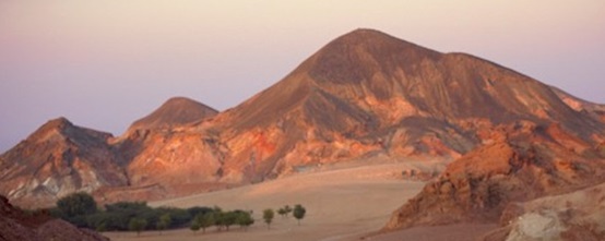 Image: Mountains and sand drifts, Sir Bani Yas. Source: https://abudhabiculture.ae/en/experience/cultural-landscapes-and-oases/sir-bani-yas-island
Archaeology
For our novel, Past Remembrance, we wrote a story involving the 7th/8th century church and the monastery on the island. However, archaeological evidence of human occupation prior to and beyond this exists.
To date, the earliest evidence of human activity on Sir Bani Yas comes from two small flint tool scatters identified during a 1992 field trip by the Abu Dhabi Islands Archaeological Survey. The scatters are approximately 7000 years old and date to the Neolithic Period (Beech, 2009, p.108; Hellyer, 1993, p.16; adias-uae.com, n.d.).
A surface survey on the southwest coast of the island recorded a small Bronze Age mound dated to the 2nd millennium BCE. Sherds of Barbar ‘red-ridged ware’ recovered from the site were identified by Beatrice de Cardi and originated from Bahrain (Beech, 2009, p.108; Kaabi & Meqbali, 2018, p.141). A geophysical survey of the mound in the late 1990s prompted later fieldwork and the excavation of a roughly oval structure. The various artefacts include pottery sherds from storage vessels, animal bones, shells, a fishhook and a Dilmun stamp seal (Kaabi & Meqbali, 2018, pp.141-149). This stamp seal, in combination with the Barbar pottery sherds, shows a clear link with Bahrain and the surrounding area.
 Image: Dilmun stamp seal - click to enlarge (Image courtesy of Hélène David-Cuny)
During their 1992 survey, the Abu Dhabi Islands Archaeological Survey identified a variety of sites dated to the 7th / 8th centuries CE (Beech, 2009, p.109). These included a series of courtyard houses, and the church and monastery. Excavation took place over four, approximately month-long seasons from 1993 to 1996 (Elders, 2001, pp. 47-48; Carter, 2008, p. 73; adias-uae.com, n.d.).
At first, the function of the main building was unknown. It was not until 1994, with the recovery of plaster crosses from the survey and the subsequent excavation of the building in 1995, that archaeologists confirmed it as a church (Carter, 2008, p. 73; King, 1997, p.226; Beech, 2019, pp. 5–6).
The church was built in two phases. Along with a ‘provisional structure’, the first phase included an unfinished northern aisle. The second phase saw the completion of the northern aisle, the floors lined with fine white plaster, and a narthex added at the western end (Elders, 2001, pp. 50-51). A narthex is a narrow, enclosed porch running across the entrance to an early Christian church.
We may describe the completed church plan as having a central nave flanked by northern and southern aisles, a square apse or chancel flanked by two square rooms. The narthex lay at one end of the structure, and a possible bell-tower at the other (Carter, 2008, p. 73).
 Click image to enlarge - Location of the church and monastery site in relation to the original shoreline (K. Davis after Beech, 2019; after Carter, 2008).
The exterior of the church was decorated with string courses made up of grape clusters, vine leaves and Christian crosses. The edges of a round arched window were also decorated in this kind of plaster design. There is some suggestion of red colouring once decorating the plastered archways inside the church (King, 1997, pp. 228-229).
Left and top right - Decorated plaster fragments from east end of the church (Beech, 2019, pp. 14-15).
Bottom right - Plaster decoration from exterior of the church (Beech, 2019, p.16).
Excavation of the northern dormitory also occurred during the 1994 season. Archaeologists discovered the remains of a kitchen, identified through charcoal deposits, blackened pots, animal and fish bones, crabs, and shellfish remnants (Beech, 2009, p.106). In Past Remembrance, Barinos’ cell is next to the kitchen.
A single Christian burial was discovered at the church site near the east gate to the complex. Unfortunately, a tree planting programme unknowingly damaged the remains prior to excavation and only part of the legs, ribs, and left arm were preserved. The burial was 145 centimetres deep, 30 to 50 centimetres wide, and covered by a large, black flint slab. The skeleton lay on its back in an east-west orientation in line with the middle of the church. No artefacts were associated with the burial (Elders, 2001, pp. 52-53).
In Past Remembrance, we researched the description of the burial and wrote it into our storyline. For the sake of the plot, we attributed the damage to an otherworldly tree root, rather than human intervention. The black flint slab also plays a prominent role in the story.
Archaeologists do not know who is buried beside the gate, however, there has been some speculation it may have been someone important to the monastery such as the church founder, an abbot or a saint (Elders, 2001, p.53). There is no concrete evidence to support or refute this idea. However, it is an interesting notion for an archaeological adventure story with paranormal elements.
Outside the church and monastery complex, several courtyard houses, complete with water cisterns, were identified. The houses were constructed using sandstone blocks and gypsum plaster and are likely contemporary with the church and monastery complex (Elders, 2001, p. 53). It has been suggested these houses may have been used by senior members of the church (Elders, 2001, p.53), or monk’s living quarters (Carter, 2008, p. 75).
The church and monastery were eventually abandoned when Islam became the dominant religion in the area. However, scattered, temporary hearths throughout the complex suggest human activity after abandonment (Elders, 2001, p52).
During the Late Islamic period (to the last few hundred years), evidence mostly in the island's north, of pottery scatters, marine butchery sites, campsites, a dry-stone wall mosque, tower, water cistern, salt mine, and cemeteries, indicate occupation continued (Beech, 2009, p. 109).
Written Sources
Historically, the first known reference to the island comes around 1590, from a Venetian jeweller, Gasparo Balbi, who writes of Sirbeniast as a source of pearls. During the first half of the 19th century, British naval officers described the island in their lower Gulf surveys (Beech, 2009, p.100). For instance, British navigators report in 1823 that Suwaidan bin Zayed arrived on the island in 1822.
“In November last he proceeded to Muscat, when he received some presents from the Imaum. And since his return he has I hear gone to establish himself in the island of Seer Beniyas which is the Southern-most of the group lately discovered…”
(King, 1998, p. 12)
Survey vessels of the East India Company produced a number of reports and maps between 1820 and 1829, including a detailed account Sir Bani Yas and surrounding waters (King, 1998, p. 12).
In 1856, the British captain, Brucks writes:
“This island is rather high, having a peak in the centre; it is seventeen miles in circumference, and appears of volcanic origin. On the Southern side, a small cove [Khawr Daᶜsa or Meriton Bay], with five fathoms of water in it, and three fathoms in the entrance.”
(King, 2008, p. 13)
 Image: Section of a map by John Bateman from 1826 showing Sir Bani Yas island (Qatar Digital Library, n.d.)
The island is also detailed in The Indian Directory of 1891 and The Persian Pilot of 1932 (King, 1998, pp. 13-15).
More recently, a 1966 British Admiralty map shows the location of a sweet-water well near the monastery site (Elders, 2001, p. 56).
The Last 50 Years
The late President HH Sheikh Zayed bin Sultan Al Nahyan began a revitalisation and greening programme on the island during the 1980s. A large tree planting operation, and introduction of gazelle, oryx, llama, rhea, giraffe, ostrich and various other species of birds and animals, created an impressive wildlife sanctuary (Beech, 2009, p. 101). This sanctuary is currently one of the major attractions on the island. Sir Bani Yas is home to many protected and endangered species and runs several successful breeding programmes (Keyrouz, 2015).
The island has also seen the development of tourist resorts popular for ‘staycations’. Coupled with the above environmental initiatives, the island has won international recognition and awards, such as the World’s Leading Sustainable Tourism Destination Award in 2014 and 2015 (Botros, 2014; WAM, 2015).
In 2013, Sir Bani Yas – Desert Islands received a Blue Flag by the World Wildlife Fund (WWF), in association with the Foundation for Environmental Education (FEE). This coveted designation indicates international compliance with environmental management, education and information, water quality, safety, and services (wwf.panda.org, 2013).
Between 2015 and 2016, the Department of Culture and Tourism in Abu Dhabi undertook conservation work on the church and monastery site (Abu Dhabi Culture, 2018). It is protected by fencing and tent-like roofing. The church and monastery complex, along with the courtyard houses, have become a popular tourist attraction and learning experience for school children.
In 2019, the road surface approaching the site was stabilised and upgraded to accommodate an increasing number of visitors (Soil Solutions, 2019).
One of the key themes of Past Remembrance is the preservation and use of the site as an educational tool for future generations.
 Image: Looking north-east across the church, Sir Bani Yas
Photo credit: Department of Culture and Tourism, Abu Dhabi - Experience Abu Dhabi
Bibliography
adias-uae.com. (n.d.) Sir Bani Yas - ADIAS Guide. Available at: http://www.adias-uae.com/sirbaniyas.html [Accessed 25 Feb. 2023].
Aston, E.R. (1985). A Brief Geology of Sir Bani Yas Island, Emirates Natural History Group Bulletin, 27, November 1985. Available at: http://enhg.org/bulletin/b27/27_02.htm [Accessed 25 Feb. 2023].
Beech, M. (2009). Archaeology of the Late Pre-Islamic to Early Islamic Period with a particular focus on recent discoveries on Sir Bani Yas Island, Abu Dhabi Emirate. In: New Perspectives on Recording UAE History. Proceedings of the International History Conference, National Center for Documentation and Research 40th Anniversary Conference (23-25 November 2008). National Center for Documentation and Research, Abu Dhabi, UAE. pp. 99 – 112.
Beech, M. J. (2019). The Church and Monastery of Sir Bani Yas - An Archaeological Site of the 7th and 8th centuries CE. Department of Culture and Tourism (DCT Abu Dhabi) - Site Guide Booklet.
Botros, M. (2014). Sir Bani Yas island wins world tourism award, Environment – Gulf News. Gulf News. Available at: https://gulfnews.com/uae/environment/sir-bani-yas-island-wins-world-tourism-award-1.1428262 [Accessed: February 25, 2023].
Carter, R.A. (2008). Christianity in the Gulf during the first centuries of Islam. Arabian Archaeology and Epigraphy, 19, pp. 71–108.
Elders, J. (2001). The lost churches of the Arabian Gulf: recent discoveries on the islands of Sir Bani Yas and Marawah, Abu Dhabi Emirate, United Arab Emirates. In: Proceedings of the Seminar for Arabian Studies, 31: pp. 47 – 57.
Hellyer, P. (1993). New discoveries on Dalma and Sir Bani Yas. Tribulus (Journal of the Emirates Natural History Group) 3.2, p. 16.
Kaabi, A. K. A., & Meqbali, A. A. R. A. (2018). New light on Bronze Age trade in the Arabian Gulf: a Dilmun trading port on Ṣīr Banī Yās island, UAE. Proceedings of the Seminar for Arabian Studies, 48, 141–149. http://www.jstor.org/stable/45163151
[Accessed 25 Feb. 2023].
Keyrouz, W. (2015). ‘Arabian Ark’ helps save wildlife from extinction. Available at: https://phys.org/news/2015-02-arabian-ark-wildlife-extinction.html [Accessed 25 Feb. 2023].
King, G.R.D. (1997). A Nestorian Monastic Settlement on the Island of Ṣīr Banī Yās, Abu Dhabi: A Preliminary Report, Bulletin of the School of Oriental and African Studies, 60.2, pp.221-235.
King, G.R.D. (1998). Abu Dhabi Islands Archaeological Survey - An Archaeological Survey of Sir Bani Yas, Dalma and Marawah: Season One. Trident Press: London.
Abu Dhabi Culture. (2018). Sir Bani Yas Church and Monastery. Available at: https://abudhabiculture.ae/en/experience/historic-landmarks/sir-bani-yas-church-and-monastry [Accessed 25 Feb. 2023].
Qatar Digital Library (n.d.) 'Sheet 2nd.', British Library: Map Collections, IOR/X/3635/36/2, in Qatar Digital Library <https://www.qdl.qa/archive/81055/vdc_100138047474.0x000001>
[accessed 17 March 2024]
Soil Solutions. (2019). Sir Bani Yas Island – Project Report for Department of Culture & Tourism. Available at: https://www.soilsolutions.com/wp-content/uploads/2019/07/Updated-SdIR-BANI-YAS-Project-Report.pdf [Accessed 26 Feb. 2023].
WAM. (2015). Sir Bani Yas Island crowned Sustainable Tourism Destination. Khaleej Times. Available at: https://www.khaleejtimes.com/uae/sir-bani-yas-island-crowned-sustainable-tourism-destination [Accessed 25 Feb. 2023].
wwf.panda.org. (2013). The UAE collects more Blue Flags; 12 more reasons to enjoy the UAE coastline. [online] Available at: https://wwf.panda.org/wwf_news/?210991/The-UAE-collects-more-Blue-Flags-12-more-reasons-to-enjoy-the-UAE-coastline [Accessed 25 Feb. 2023].